Operation Meghdoot was the codename for the Indian Armed Forces’ operation to seize control of the Siachen Glacier in Kashmir, precipitating the Siachen conflict. Executed in the morning of 13 April 1984 in the highest battlefield in the world, Meghdoot was the first military offensive of its kind.
April 13, 1984, was when India first deployed its men at Siachen. Thirty four years on, with 163 casualties in the past decade and nearly 900 overall, the soldiers continue to remain on this icy, barren land.
The story of Siachen didn’t start in 1983. Its genesis lies in the partition of India and the ensuing wars between India and Pakistan over Kashmir. At the end of the UN-brokered ceasefire in 1949, India and Pakistan agreed on a ceasefire line (CFL) in undivided Kashmir as per the Karachi Agreement of 1949. The eastern most stretch of the ceasefire line was not demarcated beyond a point called NJ9842 since it was inhospitable and uninhabited. It simply said that from NJ9842, the line would run “thence North to the glaciers” — the Siachen glacier, the Rimo and the Baltoro.
As the late Lt General S K Sinha, who was the secretary of the Indian delegation, later wrote, “No one at that time thought that military operations could take place at the forbidding heights beyond NJ9842. In any case, the ceasefire line was only something temporary. After plebiscite, it would become irrelevant. Thus, we drew a straight line running north from NJ9842 to the glaciers. It is easy to be wise after the event. It would have been better if the line beyond NJ9842 had not been left vague.”
The 1949 ceasefire line was revalidated as the Line of Control (LoC) by the Suchetgarh Agreement of December 1972, in accordance with the Simla Conference. The LoC closely assimilated military advances made by either side in J&K in the 1971 war but did not make any changes to the line beyond NJ9842. Uninhabited, the area was considered beyond the ambit of any military operations by both sides.
But Pakistan had begun making certain cartographic changes to the ceasefire line after the 1962 war which were soon reflected by the US defence mapping agency, a global benchmark for cartography. Between 1964 and 1972, Pakistan began depicting the ceasefire line as extending from NJ9842 to a point just west of the Karakoram Pass, not northwards as the agreement said. Global mountaineering maps soon started portraying this as the authentic and internationally accepted CFL-LoC, backed by mountaineering legends.
it had become obvious to the Indian side that Pakistan army was getting ready to physically move into the Siachen glacier. Intelligence reports had spoken of Pakistani troop movements towards Siachen while R&AW had picked up information on Pakistan army buying large quantity of high-altitude gear from Europe. India then decided to act swiftly in order to prevent Pakistan from occupying the Siachen glacier. The move was approved by Prime Minister Indira Gandhi.
The task of occupying the Saltoro ridge was given to 26 Sector, commanded by Brigadier Vijay Channa, who was tasked with launching the operation between April 10 and 30. He chose April 13, supposedly an unlucky date, because it was the Baisakhi day, when the Pakistanis would be least expecting the Indians to launch an operation.
At 5.30 am on April 13, the first Cheetah helicopter, carrying Captain Sanjay Kulkarni and one soldier, took off from the base camp. By noon, 17 such sorties were flown and 29 soldiers were heli-dropped at Bilafond La. Soon, the weather packed up and the platoon was cut off from the headquarters. The contact was established after three days, when five Cheetah and two Mi-8 helicopters flew a record 32 sorties on April 17 to Sia La. That same day, a Pakistani helicopter flew overhead to see Indian soldiers already deployed at the glacier.
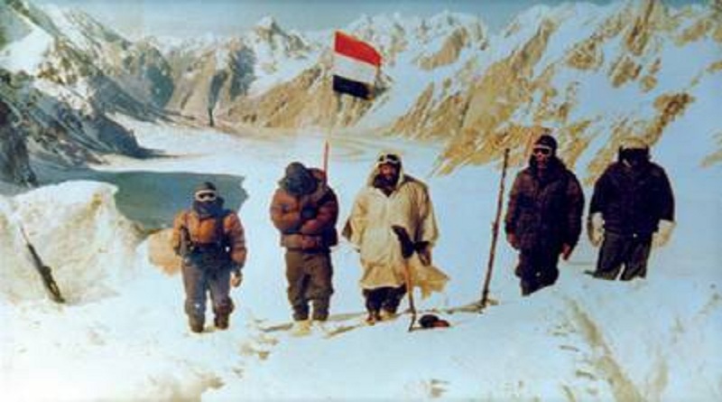
Soon the whole glacier was secured, in an operation christened Meghdoot. Lt General Chibber wrote in an official note: “The two main passes were sealed off. The enemy was taken completely by surprise and an area of approximately 3,300 sq km, illegally shown as part of PoK on the maps published by Pak and USA were now under our control. The enemy had been pre-empted in their attempt to occupy the area claimed by them.” The glacier continues to be occupied till date.
